Location, Geography, & Climate
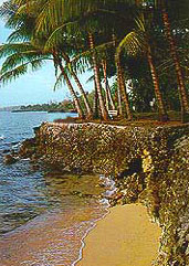
![]() Papua New Guinea occupies the eastern half of the rugged tropical island of New Guinea(which it shares with the Indonesian territory of Irian Jaya) as well as numerous smaller islands and atolls in the Pacific. The central part of the island rises into a wide ridge of mountains known as the Highlands, a territory that is so densely forested and topographically forbidding that the island's local peoples remained isolated from each other for millennia. The coastline is liberally endowed with spectacular coral reefs, giving the country an international reputation for scuba diving. The smaller island groups of Papua New Guinea include the Bismarck Archipelago, New Britain, New Ireland and the North Solomons. Some of these islands are volcanic, with dramatic mountain ranges, and all are relatively undeveloped.
Papua New Guinea occupies the eastern half of the rugged tropical island of New Guinea(which it shares with the Indonesian territory of Irian Jaya) as well as numerous smaller islands and atolls in the Pacific. The central part of the island rises into a wide ridge of mountains known as the Highlands, a territory that is so densely forested and topographically forbidding that the island's local peoples remained isolated from each other for millennia. The coastline is liberally endowed with spectacular coral reefs, giving the country an international reputation for scuba diving. The smaller island groups of Papua New Guinea include the Bismarck Archipelago, New Britain, New Ireland and the North Solomons. Some of these islands are volcanic, with dramatic mountain ranges, and all are relatively undeveloped.
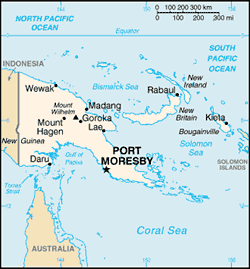 Nearly 85 percent of the main island is carpeted with tropical rain forest, containing vegetation that is a combination of Asian and Australian species. The country is also home to an impressive variety of exotic birds, including virtually all of the known species of birds of paradise, and it is blessed with more kinds of orchids than any other country.
Papua New Guinea's climate is tropical, as one would expect in a country located just south of the Equator. December to March is the wet season, although occasional rain falls year-round. While Port Moresby, the capital, and other towns on the coast are quite hot in the summer months, temperatures are considerable cooler in the Highlands. July, August, and September are the best months for trekking vacations.
History and People
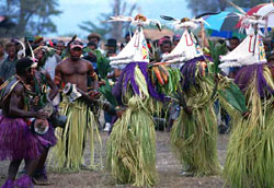
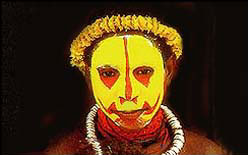 The first inhabitants of Papua New Guinea, probably migrants from the Indonesian archipelago, arrived about 50,000 years ago. These migrants arrived in several waves, and the land that they encountered had a remarkable effect on cultural development. Because New Guinea's terrain is marked by imposing mountains and extremely rugged territory, different population groups developed in virtual isolation. Each group developed its own language and its own tribal culture, a development that gives Papua New Guinea one of the world's most diverse and fascinating cultural landscapes.
 The first contact with the island by Europeans occurred in the early 16th century, when the Portuguese explorer Jorge de Meneses sighted the country and named it Ilhas dos Papuas (Land of the Fuzzy-Haired People). However, it wasn't until the mid-1800's that European missionaries and traders began to settle on the island, and even those few settlers limited their presence mostly to the accessible coastal areas. Over the next several decades Papua New Guinea was claimed by the Germans, the British, and the Dutch, but it came under the control of Australia after World War One. The inland Highland region, thought to be too inhospitable for habitation, wasn't even explored until the 1930s. Astoundingly, European explorers in search of gold instead discovered over one million people, living in fertile mountain valleys and in cultures that hadn't changed since the Stone Age. By the 1960s there had emerged a significant independence movement in the country, and in 1975, after a brief period of internal autonomy, Papua New Guinea declared its full independence.
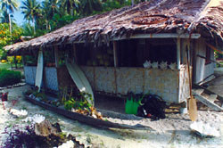 The people can be divided into four ethnic groups: New Guineans (from the north of the main island), Papuans (from the south), Highlanders, and Islanders. There is, however, considerable cultural variation within each of these groups. The peoples of the south coast were notorious for headhunting and cannibalism before the arrival of the Europeans. Many people still live in small villages and follow traditional tribal customs. Although English is the official language in schools and government, almost 800 distinct languages are spoken in the islands.
Transportation
Transport in Papua New Guinea is in many cases heavily limited by the mountainous terrain. The capital, Port Moresby, is not linked by road to any of the other major towns and many highland villages can only be reached by light aircraft or on foot.
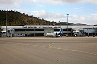
Air travel is the single most important form of transport in Papua New Guinea. Aeroplanes made it possible to open up the country during its early colonial period. Even today the two largest cities, Port Moresby and Lae, are only directly connected by planes.
Jacksons International Airport is the major international airport in Papua New Guinea, located 5 miles from Port Moresby.
As of 1999, Papua New Guinea has a total of 19,600 km of all weather highway, of which only 686 km is sealed. Where there are roads there are many privately operated Public Motor Vehicles (PMVs), mostly minivans, which function as unscheduled buses. In 2001, the Philippines government had given PNG several jeepney units for Papuan citizens to use.
The longest road in the country is the Highlands Highway which links Lae and Madang to the Highlands region. The Boluminski Highway links Kavieng and Namatanai in New Ireland Province. A highway linking Wewak in East Sepik Province and Vanimo in West Sepik Province was completed in September 2007. The Kiunga-Tabubil Highway is a privately maintained road that links highland communities in the Western Province.
Papua New Guinea has no major railways, but some mine sites have disused tracks. During the period of German colonial control at the start of the 20th century numerous plantation railways had been constructed in German New Guinea. These were built near the settlements of Madang and Rabaul.[2] After the fall of German New Guinea to the Australians in the First World War the railways ran into disrepair.
In September 2007 a mining company has proposed to build a new railway to link the coast with a copper-molybdenum at Yandera mine in Madang province.
No comments:
Post a Comment